|

SAVOIE
- Geography
 Savoie is the name
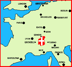
of an old country annexed by France in 1860. The traditional
frontiers of Savoie have not changed since the annexation: Savoie
lies East of France, West of Italy, and South of Switzerland
and Lake Geneva, at the crossroads of the Alps. Savoie measures
approximately 100km (60 miles) across, and 150km (90 miles) North
to South. The nearest international airports are in Geneva, just
across the border from northern Haute Savoie; Lyon, some one
hundred miles to the west, and Milan, in Italy, across the Alps
to the east. Savoie is the name
of an old country annexed by France in 1860. The traditional
frontiers of Savoie have not changed since the annexation: Savoie
lies East of France, West of Italy, and South of Switzerland
and Lake Geneva, at the crossroads of the Alps. Savoie measures
approximately 100km (60 miles) across, and 150km (90 miles) North
to South. The nearest international airports are in Geneva, just
across the border from northern Haute Savoie; Lyon, some one
hundred miles to the west, and Milan, in Italy, across the Alps
to the east.
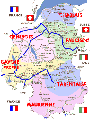 The former country
of Savoie, whose six traditional provinces are shown in the map
at left, is now divided into two French départements
(states) called Savoie and Haute Savoie. Savoie, long an
independent nation, is now part of the nation-state of France,
though some regionalists have as a goal the separation
of Savoie from modern France. The former country
of Savoie, whose six traditional provinces are shown in the map
at left, is now divided into two French départements
(states) called Savoie and Haute Savoie. Savoie, long an
independent nation, is now part of the nation-state of France,
though some regionalists have as a goal the separation
of Savoie from modern France.
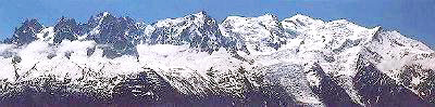
The tallest mountain
of the Alps, Mt. Blanc, is in Haute Savoie, as are the popular
resorts of Chamonix, Courchevel, Megève, and St Gervais,
among others. The Olympic city of Albertville, the old royal
capital of Chambéry and the Abbey of Hautecombe are in
the much more agricultural département of Savoie, which
produces excellent white wines.
 Savoie and Haute Savoie are well known for their
ski resorts, but also for their beautiful lakes,
(Lac du Bourget, Lac d'Annecy, Lac d'Aiguebelette), which attract
huge numbers of summer vacationers. Savoie and Haute Savoie are well known for their
ski resorts, but also for their beautiful lakes,
(Lac du Bourget, Lac d'Annecy, Lac d'Aiguebelette), which attract
huge numbers of summer vacationers.
 The city of Annecy, with its lovely
canals, "Vieille Ville" (Old City) and hilltop castle,
is considered to be one of the most beautiful cities in Europe;
it hosts an international festival of animated films (every other
year, in May), as well as a huge fireworks display (La Fête
du Lac, in August). In addition, the old section of the city
is filled with restaurants that prepare the reknowned cuisine
of the region. It is a very popular destination for tourists
from around the world. The city of Annecy, with its lovely
canals, "Vieille Ville" (Old City) and hilltop castle,
is considered to be one of the most beautiful cities in Europe;
it hosts an international festival of animated films (every other
year, in May), as well as a huge fireworks display (La Fête
du Lac, in August). In addition, the old section of the city
is filled with restaurants that prepare the reknowned cuisine
of the region. It is a very popular destination for tourists
from around the world.
 SAVOIE: A Brief
History
SAVOIE: A Brief
History
end of
page
|